
90%
clean-up cost reduction
180
miles of pipeline mapped
$1.5M
cost of just three leaks
Thousands of miles of pipelines stretch out across the U.S., carrying oil and gas from wells to refineries. With any pipeline, corrosion can cause leaks and constitute a significant risk. Not only is a leak potentially catastrophic to the environment, but it can also cost hundreds of thousands of dollars to remediate and take years to clean up. Inspecting pipelines is a necessity that’s challenging, time-consuming, and expensive for O&G companies.

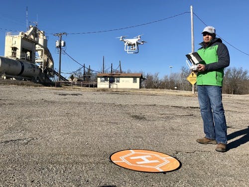
Instead of relying on ground crews to detect leaks TSC uses drones to map extensive pipeline networks.
Environmental, engineering, and construction services company Trinity Services and Consulting, LLC (TSC) frequently works with O&G companies to monitor pipelines, conduct soil testing, and, in the case of a spill, provide clean-up services. Instead of relying on ground crews and manned flights to monitor and detect leaks, it uses drones to map extensive pipeline networks to protect the environment and to keep client inspection and remediation costs down.
Saltwater Leaks Can Spell Disaster for Properties and Farms
Not all pipelines transport oil or gas. Saltwater is a common byproduct of oil extraction. Also known as produced water, wells pump it up along with oil. Producers must separate the saltwater from the oil and then dispose of it properly. Nationwide, thousands of miles of pipeline transport saltwater to disposal points.

A leak from an underground pipe can spell disaster for nearby farms and properties.
For one of its clients, a large O&G company, TSC used drones to perform vegetation indexing to identify possible saltwater leaks along two separate sections of the client’s pipeline in northern Oklahoma. In this region, produced water has a particularly high level of salinity. A leak from an underground pipe can spell disaster for nearby farms and properties. Saltwater kills vegetation, including row crops. Produced water leaks usually aren’t detected until there is plant kill-off.
Saltwater contamination is much more difficult to remediate than oil. Clean-up costs from a single spill can soar into the hundreds of thousands of dollars, and eliminate an entire harvest for local farmers. Over the past two years, TSC’s client had experienced three saltwater leaks that resulted in more than $1.5 million in total clean-up costs.

For the project, TSC used DJI Phantom 4 Pro drones to fly over 180 miles of pipeline.
Mapping 180 Miles of Produced-Water Pipeline
For the project, TSC used Phantom 4 Pro drones to fly over 180 miles of pipeline to make a map and use a vegetation index to identify areas where potential leaks may be occurring. The project offered many challenges. The team used DroneDeploy’s Linear Flight Plan app to plan the flights in advance. TSC’s UAS pilots, aided by visual observers for Part 107 compliance, made hundreds of flights to cover the many twists and turns of the client’s two pipeline networks.
The app made a big difference: Shane was able to fly the drone until the battery was depleted, resulting in fewer flights and a 30% time savings. The drones captured more than 50,000 photos, which were processed in DroneDeploy. Using the ArcGIS integration, TSC technicians exported maps from DroneDeploy to create a single map in ArcGIS with indices and mark-ups.
DroneDeploy’s flight app is my favorite, and the linear mapping was great. The ability to do all the processing online without tying up computers here at the office is another huge plus.
Shane McKinzie, Aerial Services Manager, TSC
Catching Leaks Early Through Efficient Inspection Saves the Environment
Examining the vegetation index, TSC identified specific areas of concern. TSC tagged about 90 regions of interest along the pipeline and delivered high resolution, up-to-date imagery to the client, so it could analyze the photos and follow up with ground crew inspections, if necessary. If the client detects a single leak, it will see a significant ROI.

Examining the vegetation index, TSC identified specific areas of concern with DroneDeploy.
By using drones, TSC will be able to help its client monitor pipeline more often, at a much lower cost. Without TSC’s drone services, the client would have to deploy foot patrols or manned aircraft to search for potential leaks. By using drones and aerial imagery to monitor pipelines, leaks can be caught early, saving up to 90% on clean-up costs and preventing farmland from being damaged.
DroneDeploy was the right tool for this particular project because it was easy to use, cloud-based, fast, and had no hardware requirement.
Shane McKinzie
Even better, this initial map will serve as the foundation for continued surveillance of the pipeline. Comparing future maps to it will allow the client to detect vegetation changes over time and identify patches that are getting worse.
Taking a Proactive Approach
TSC is working to transform the pipeline inspection process from reactive to proactive. This approach is crucial with produced water pipelines because no regulation mandates inspections, so they’re inspected less often than oil and gas pipelines.
Using drone imagery and plant health analysis with DroneDeploy, TSC offers more efficient and frequent monitoring of produced water pipelines, so the client no longer has to wait until a landowner or farmer complains about plant kill-off to take action. This approach will limit environmental damage, preserve American farmland, protect crops, and save its client millions of dollars in remediation costs over time.


