1400
quarry acres
$28,500
annual savings
228
labor hours saved annually
The aggregate industry usually relies on time-consuming ground surveys to gather the elevation data needed to make water-management decisions. Water management and extraction from below the water table go hand in hand. If it isn’t managed well, surface water and groundwater can collect in the quarry and affect day to day operations.
Drone maps enhance the development of the water management plans for quarries. By using drones to survey an Ontario aggregate quarry, Tecia White of Whitewater Hydrogeology Ltd. not only improved job site safety and gathered a richer set of data, but she did it all twenty times faster than a traditional ground survey.

Tecia White, President at Whitewater Hydrogeology Ltd.
Tecia White has over 19 years of experience as a geologist and hydrogeologist. She spends most days solving hydrogeological challenges through her environmental consulting firm, Whitewater Hydrogeology Ltd. The firm primarily works with aggregate operators in southern Ontario to help them understand the influence of existing and proposed operations on the groundwater and surface water regimes. A little over a year ago, Tecia began offering a new service to Nelson Aggregate Co. and began incorporating drones into her work as a way to analyze stockpile volumes. It wasn’t long before she discovered that drone maps and models could give her far more than just volumetric data.
Everyone should be using drones for stockpile analysis. It’s miles ahead of standard surveying.
Tecia White, President, Whitewater Hydrogeology Ltd.
She began using drone-generated maps and 3D models as a tool for gathering elevation data and creating water management plans at Nelson Aggregate’s Uhthoff Quarry. They've also taken the use of the drones one step further by using then to inspect the operating condition of large production equipment.
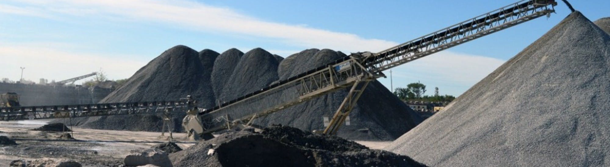
Over the past year, she has fired up her drone nearly a dozen times at six of Nelson Aggregate’s gravel pits and limestone quarries. What began as a way to inventory stockpile materials, quickly became a key tool in her everyday workflow.

The 1400 acre Uhthoff quarry supplies various limestone products to the construction industry. Tecia has used her DJI Phantom 4 several times each season to map major stockpiles, then used DroneDeploy’s stockpile analysis app to inventory the materials. In a matter of minutes, she was able to measure the cut, fill and volume of any stockpile she mapped.
She also uses DroneDeploy to conduct aerial surveys of the quarry multiple times throughout the year. From creating drainage and discharge plans to estimating the volumes of overburden material that must be removed, Tecia used drone-generated data in nearly every aspect of her work at the quarry.
Aerial Surveys are Twenty Times Faster than Ground-Based Methods
Continual changes across the landscape of the quarry makes water management an ongoing process. At a site like the Uhthoff quarry, elevation data is usually gathered twice a year. But before drones entered the picture, this information could only be gathered by ground survey. It takes upwards of twenty man hours to survey and process data for a 1400 acre quarry. And even then, the survey would only gather the elevations of individual stockpiles, and occasionally spot elevations for the quarry floor.

Hydrogeologist Tecia White used DroneDeploy’s stockpile analysis tool during her work at a southern Ontario aggregate quarry.
An aerial survey of the Ontario site, on the other hand, takes Tecia just two hours to complete, including both flight time and data extraction. Tecia’s drone not only gathered accurate elevation data for the entire 1,400 acre site, but it did so twenty times faster than a ground-based survey of just individual stockpiles. This represents a far greater data set and a ninety-five percent reduction in man hours.
A ninety ninety-five percent man hour reduction is impressive enough, but the biggest return-on-investment can be seen by looking at time and money savings over all six of Nelson Aggregate sites. A bi-annual survey of six quarry sites represents about 240 man hours. Compare that to just twelve hours needed to complete twice-yearly aerial surveys at all six sites. That’s a savings of 228 man hours.
In terms of money savings, the results are no less impressive. Nelson Aggregate spends about $3,000 to subcontract out a single ground survey. Bi-annual ground surveys of all six quarries cost around $36,000 total per year. Factoring in drone equipment and software subscriptions, the same amount of aerial surveys cost just $7,500 — $28,500 less than a ground survey. This represents nearly 80% in costs savings.
By replacing ground-based surveys with bi-annual aerial surveys, Nelson Aggregate saved a total of 228 man hours and $28,500 across six quarry sites.

Elevation map of the Ontario aggregate quarry.
Drones Improve Worker Safety at Aggregate Operations
With steep slopes, unstable rock faces and lots of heavy machinery, rock quarries can be dangerous places to work. Aggregate operators are always looking at field methods to improve the safety of the work environment. As Tecia sees it, one of the greatest benefits of drones is their ability to improve worker safety by removing the requirement to have people on the ground in and around the operation areas (stockpiles, equipment).
Anytime you can reduce the number of workers in a quarry it is going to reduce the chance of injury and improve overall safety
Tecia White, Whitewater Hydrogeology Ltd.
Instead of spending twenty hours navigating stockpiles and quarry terrain to complete a ground survey, flights are launched outside of the operating quarry and pit working areas. All of the elevation data needed for the Ontario site is now gathered without ever setting foot within the operation. This improvement alone is worth the investment in drone technology.
“Anytime you can reduce the number of workers in a quarry it is going to reduce the chance of injury and improve overall safety,” says Tecia. “Drones allow us to do that.”

3D model of the Ontario quarry site. Drones allow Tecia to gather additional information she would not get with traditional survey methods.Explore the model.
Drone Maps and Models Give Hydrogeologist a Rich Data Set
Although Tecia first set out to gather elevation data and stockpile information, she soon discovered that her drone provides a rich set of data that is useful in many other aspects of quarry management. “With a surveyor you’re just getting the data,” says Tecia. “There are no maps or models.”
Now, with the help of DroneDeploy, Tecia uses her drone maps for far more than elevation data and stockpile analysis. With accurate drone maps, DroneDeploy’s built-in volume tool is used to estimate the amount of overburden material that must be removed prior to the extraction of aggregate. High-resolution 3D models allow her to remotely assess progressive and final rehabilitation work. She also uses the models to conduct aerial circle checks of heavy machinery, searching for issues that would not be visible from the ground.
Speaking to others who work in hydrogeology and quarry management, Tecia has these words of encouragement about using drones: “Embrace the change and move forward. This technology is working.”


